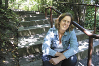
‘Hardcore walker’ brings feet-first research to detail Island byways
Nursing a large blister from a recent hike on Mt. Rainier’s Wonderland Trail, Mercer Island resident Kris Kelsay has always been a big-time walker. So it should come as no surprise to friends and family (and lucky for Mercer Island) that she has just published a book about it: “Walk! Mercer Island.”
Since moving here in 1993, Kelsay has gravitated toward the Island’s many meandering paths and walkways.
Stopping by the old Looks Drug Store — now occupied by Tony Maroni’s Pizza and Seven Stars Chinese restaurant — one day, she happened upon an indispensable green pamphlet stapled down the side containing several hand-drawn maps of the Island’s many paths, scenic walks and cut-throughs. Growing up on a steady diet of wooded trails and hills in the San Francisco Bay area, she wanted to get outdoors and into the Island’s natural beauty with her then 9-month-old son.
“You grow up in the woods, you’re an outdoor person,” she said.
Since then, the dog-eared and worn walking pamphlet has never been updated while Kelsay discovered a number of other unmentioned trails, and the City of Mercer Island added or improved trails and created new parks. So earlier this year, she took it upon herself to share the hidden gems of nature, beautiful vistas and the quickest way to reach the local public landing for a dip in the lake on a hot summer’s day.
“I thought to myself, somebody needs to do this,” Kelsay said. “Even the hardcore walkers — I’ve known of paths they didn’t know about.”
There are three main sections to the book: trail guides, guided walks and how to get from A to B.
The walks are both rated in difficulty and chock-full of Island history, such as how the Fluery Trail got its name, how the entire Island was logged 100 years ago, where the first retail store on Mercer Island was located and more. It also has a practical side, detailing walks that stretch less than a mile while driving there is a four- or five-mile drive: South Mercer Playfields to the Beach Club, Youth Theatre to Luther Burbank Park or Bicentennial Park to Proctor Landing.
“With this book,” she said, “you can take that trail that you always wondered where it went and you know you’re going to get somewhere.”
Kelsay’s work as a high-tech consultant has slowed down lately, so she has been spending more time walking around the Island and reflecting on her volunteer efforts as an art docent for the Mercer Island School District — as well as efforts to improve sidewalks and school-walking routes, encouraging local school children to walk more often (her husband is also the district’s transportation director). She said the book was a great way for people to reconnect with their community, encourage children to say active and healthy, and to take a measure of pride in where they live.
Marking a new trend enabled by technology, Kelsay self-published “Walk! Mercer Island” through do-it-yourself software from the Web site Createspace.com to layout and order micro-shipments of her book. She said creating an actual book in the past, complete with an International Standard Book Number (ISBN) on the back, wouldn’t have been possible without the new technology because larger publishing houses were unlikely to publish a book with such a small potential audience.
“Personal info to connect people where they are is the new trend right now,” Kelsay said. “It’s all about localism.”
It may not reach the New York Times bestseller list, but reports from the businesses selling them are overwhelmingly positive. At $19.95 a book, Kelsay is not planning on making much money on her book. But the whole experience of publishing her first book has been a unique one that she has enjoyed.
“It’s been kind of fun; there’s somebody there in the book store, and they’ve got it in their hands, looking it through — it’s fun to watch that,” she said. Roger Page at Island Books recently ordered another shipment and hosted Kelsay for a book signing on Aug. 2. The book is reportedly only available at local merchants, including Finders Gifts, Alpenland, Island Books and Chick’s Shoes.
“It’s about the whole ‘stay-cation’ thing,” she said. “Why not do something here? There’s plenty to explore.”
Mercer Island Councilman Dan Grausz, the current chair of the Parks and Recreation Committee, said he couldn’t agree more.
“The more people use the Island’s trails, the better,” he said. “This is an oasis here. You’ve got to get out and enjoy it.”
The city publishes a bike and trail plan every few years, but “Walk! Mercer Island” is much more detailed.
According to Grausz, the city has indeed created several new trails and a greenbelt in an attempt to create more connectivity on the Island, such as along East Mercer between 53rd and 68th Streets and up to the Parkwood neighborhood and greenbelt from S.E. 63rd Street.
Mayor Jim Pearman, a former Parks and Recreation board member several years ago, was happy to hear that someone had taken on the project of updating and promoting the Island’s local walking trails.
He said that he had walked many of the trails himself since the time he was a Boy Scout and would be surprised if he found a trail that he didn’t know, as he recently skimmed a copy several days ago. Pearman said it seemed as if the Island had fewer traffic issues back when he graduated from Mercer Island High School in 1976 in a class with nearly 200 more students than 2009.
“There was a lot more use of bikes and trails back when I was I kid,” he said. “These kind of things ebb and flow.”


